The Adirondack Mountains
I left the Catskill Mountains and headed north to the Adirondack Mountains. I'd always heard people say New York state is beautiful and I sure can't argue with that. Once you get away from the interstates and big cities it's a very scenic place. Lots of twisty winding roads that lead through deciduous forests and the occasional small town that was invariably founded in the 1700's, something you just don't see back in Iowa.
It always rubs me the wrong way when I see a town referred to as a “village” in the midwest or when I was on the west coast; it just doesn't seem right. It doesn't fit midwest or west coast towns and the only point seems to be to endear tourists. Out here on the east coast the “village” moniker seems to fit quite well though. With centuries old large stone buildings in lush, green town centers surrounded by a cluster of beautiful houses with large old trees growing all around. They all have an old cemetary on the outskirts of town filled with plain, white, tall ,eroded head stones surrounded by an iron fence, many of which share ground with an old church. Many of the headstones are dated in the 1700's and some of the cemeteries became filled up and stopped accepting new clients back in the 1800's. These towns seem like they could legitimately be referred to as a village. Even if they aren't what you might call a village now that's what they were when they got their start.
Thursday night I'd stopped at a small book store a little south of the Adirondacks to find a good map of the area that showed some hiking trails. Unfortunately the Adirondack mountains cover a big area so it was split up over 4 or 5 different maps and I didn't know which part of the park I wanted to be in. I was the last person in the shop and they were waiting on me so they could close so I didn't have a lot of time to figure it out. I asked the owner if she knew much about the park and she said she'd only been up a few times, around the Lake Placid area. That name rang a bell and she told me I'd probably be happiest with map “742” since it showed some of the most popular places in the park and covered more area then most of the other maps. I opened the map and saw a maze of hiking trails, it looked like a winner to me. Map 742 covered the Northeast/east central portion of the park.
She walked off for a while and I grabbed a couple other hiking books of the Adirondacks to flip through and to try and get an idea of where to hike. In one of the books was a map of the park with numbers for each trail head that corresponded to the trails mentioned in the book. I noticed that very few of them were in the area covered by map 742. I decided to take a little closer look at map 742 and discovered it definitely was NOT the map I was looking for. It was mainly centered around the main highways and interstate that ran up the east side of the park. Sure there were lots of hiking trails, but they were all pretty short and left directly from trail heads on the main highway. There were also very few gravel/dirt roads shown that got you farther back into the park and off the beaten path. I made a quick judgement call to buy map 744 instead and checked out. I studied the map further in the car to figure out where I'd sleep that night and where I'd hike in the coming days. Map 744 covered the south central portion of the park, which didn't have a lot of highways running through it. It also contained quite a few dirt roads winding back into the woods. Just what I was looking for.
It rained hard on Thursday night and I was once again happy to be dry and warm sleeping in my house. Friday was supposed to be cloudy and rainy earlier in the day, clearing towards evening. I was up fairly early to bright blue skies though and I started driving to the trail head I'd picked out. To get there I'd have to drive about 6 miles down a dirt road; from there the trail head led to a few lakes as it made a large loop through the mountains. I arrived to the trail head by mid-morning but was in no rush. I still wasn't sure how many days/nights I was going to be out so while I thought about it I studied the map and mixed up some trail mix for snacks.
I looked at the map and my food supplies and planned on a 3 day, 2 night trip into the woods. It had been quite a while since I'd done any real hiking in the woods and I was looking forward to using my new backpack and sleeping bag. I planned out what my meals would be so I could pack accordingly and I got all me gear loaded up and ready to go. As always I was amazed how heavy my pack was when I picked it up, it's always a mystery where all that weight comes from! The new backpack felt great though and I found it much more comfortable to carry the heavy load on it as opposed to my other internal frame backpack. Also helping to make the load more bearable was my water purifier that I'd bought in Portland but hadn't used yet. Carrying a quart to drink on the initial hike to camp was much easier then carrying 1 1/2 gallons to last the entire trip.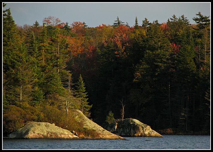 I set out down the trail towards a lean to that showed on the map at Sampson Lake, about 6 miles away. It was a great hike through the woods on the way there. There was a slight breeze blowing and the sun was shining. Many of the trees were really coming into color and quite a few others had already dropped their red and yellow leaves on the forest floor during the previous nights rain, making for a soft and colorful carpet to walk on.
There had only been one other car at the trail head parking lot and I met the owner of it as I passed by Pillsbury Lake. He and a friend had spent the previous night at Sampson lake and were going to spend this night at Pillsbury before heading out the following morning (the exact plan I had). He'd dropped his GPS while out gathering wood and was searching for it when I rain into him. We walked together on the trail until we reached the turn out for his camp and then I was on my own again.
After passing Pillsbury Lake the trail started getting smaller and smaller. Apparently not as many people continue on this far, even though it isn't very far at all and an easy hike. It was only a couple more miles from Pillsbury to Sampson but as I approached the trail didn't look like much more then a game trail for some stretches.
When I'd seen the “lean to” marked on the map I really didn't know what to expect, but I wasn't expecting much. I figured at best it would be a rickety little shelter propped up against some trees and that maybe I wouldn't actually have to pitch my tarp (left the tent behind for weight savings). All I was really expecting though was a dilapidated structure that I couldn't use but that would have a cleared area to set up camp and a fire ring of some sort. Needless to say I was shocked when I reached the small clearing where the lean-to was located. What I found was a good sized structure in very good shape, fully outfitted with pots, pans, cups, silverware, a saw, and even dry kindling. It was built out of logs and was elevated off the ground, the roof was even shingled! As soon as I got over my shock of seeing it I immediately regretted carrying the weight of some of my gear that would now be unneeded. Oh well, if I'd planned on something this nice it probably would have turned out very differently anyway or would have been occupied and I would have been kicking myself for not bringing the extra gear.
I arrived just in time since I'd started hearing some low rumbles of thunder a few hundred yards down the trail and it was just starting to sprinkle as I arrived at camp. Just after setting down my bag and getting situated a little the wind picked up and it started raining pretty good. The weather report seemed to be backwards. Instead of cloudy early and turning sunny later in the day it was the exact opposite. As I sat under my shelter waiting I began unpacking and read the entries in the travel log left in the lean-to so travelers can sign in. I was very happy to be under the lean to as opposed to be huddling under my tarp to keep dry.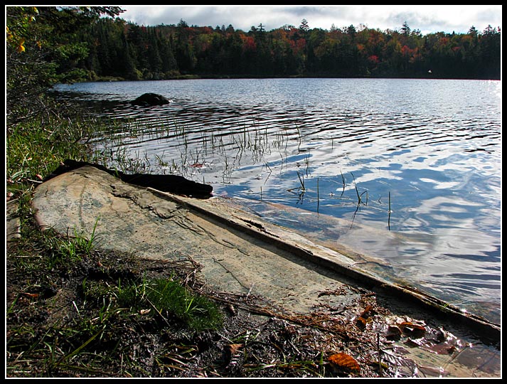 After the small storm passed the wind died off completely and the lake in front of me began to calm down. I saw a couple loons go swimming past and I got up to explore what would be my home for the next day. There was a nice fire place right in front of a lean-to and a pit toilet out back. A little farther down the trail was another fire ring and plenty of dead falls for fire wood. The lake was nice and clear with a few small islands on it. I could see a few loons and herons out in the water. On the “beach” in front of the lean-to was what was left of the bottom of a small boat.
 It was starting to get late in the day so I figured I should get some firewood lined up. It had rained quite a bit over the last few days so everything was pretty wet but fortunately I'd brought along my hatchet so I could cut and split my own to get to the dry wood in the middle. I spent about an hour preparing some wood when suddenly the skies opened up again and I was left sitting under the shelter for another 20 minutes while I waited it out. By the time the rain had stopped it was dark and I hoped that I could get a good fire going.
The farther east I drive the earlier it gets dark at night. There isn't a whole lot to do in the woods after dark and I generally don't feel like going to sleep at 7:00 so a fire is always a good thing to have. Thankfully between the dry kindling in the shelter and the dry wood I was able to cut it only took one match to get a good warm blaze going. I ate a sandwich I'd packed before I'd started earlier that day and made myself some hot chocolate before going to bed for the night. It was a very calm, very quiet night. The only sound I heard was the mice running around the lean-to.
To be continued.....
![]()
No comments:
Post a Comment